Will China sink its teeth into India’s chicken neck?
Enayet Karim: The geographical location of states is particularly important in international politics. On the one hand, geographical location can become the main source of strength of a state, on the other hand, it can also be the cause of eternal weakness of a state.
The ‘Siliguri Corridor’ included in the ‘Republic of India’ is working as a geopolitical ‘double-edged sword’. On the one hand, the corridor is playing a very important role in safeguarding India’s geographical integrity and political unity, on the other hand, the corridor can pose a serious threat to India’s national security and political stability. In fact, the Siliguri Corridor is a very important region not only for India but also in the geopolitics of South Asia as a whole.
From a purely geographical point of view, the Siliguri Corridor is a small stretch of land located in the Indian state of West Bengal. The corridor consists of Siliguri, the third largest city in West Bengal (about 62% of the city is in Darjeeling district and about 38% in Jalpaiguri district) and its surrounding areas.
The length of Siliguri corridor is 60 km. and width of 22 km, but in some places the width of the corridor is less (around 17 km). The Indian state can be divided into two territories: mainland India and North-East India. These two parts of the Indian state are connected to each other through the Siliguri Corridor.
That is, if there was no Siliguri Corridor, there would have been no land connection between Northeast India and mainland India. Note that Northeast India is completely landlocked, that is, there is no sea on the border of Northeast India. As a result, it is not possible to connect North-East India with the Indian mainland by sea.
At this stage it is necessary to give a brief introduction to North-East India. Administratively, the region is known as the ‘North Eastern Region’ (NER), and 8 of India’s 28 states are located in this region. The states are – Sikkim, Assam, Meghalaya, Tripura, Mizoram, Manipur, Nagaland and Arunachal Pradesh. Among these, the remaining 7 provinces, except Sikkim, have collectively become known as the ‘Seven Sisters’. These ‘Seven Sisters’ provinces are politically and geographically far from the center of the Indian state (the capital, New Delhi), and ethnographically and culturally, the bulk of the region is more similar to the neighboring state of Myanmar than to northern or southern India (even West Bengal).
In this situation, due to various political, socio-economic, cultural, historical and other factors, separatism (or, from a different perspective, independence movement) and various political instability (especially ethnic and religious conflicts) prevailed in the ‘Seven Sisters’ provinces, and thereby dominated the region. It is already difficult for the Indian state to maintain. Moreover, the boundaries and ownership of the region are not entirely clear, as China refers to large parts of Arunachal Pradesh as ‘South Tibet’ and claims it as part of the ‘Tibet Autonomous Region’ under China.
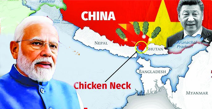
In this situation, New Delhi has to maintain a strong military presence in the region to protect India’s geographical integrity and maintain political stability in Northeast India. Moreover, the economic development of the relatively backward North-East India and the implementation of the ‘Look East’ and ‘Act East’ policies of the Indian foreign policy adopted by the Indian central government require the establishment of a broad Indian economic presence in the region. It should be noted that the main objective of ‘Look East’ and ‘Act East’ policies is to expand existing relations (especially economic and military relations) between India and South-East Asian countries and in this case North-East India acts as a bridge between Indian states and South-East Asia. But there is only one connecting link between mainland India and Northeast India, and that is the Siliguri Corridor, known as the ‘Gateway to Northeast India’. The shape of this corridor on the map is like a chicken’s neck, that’s why this corridor is called as ‘India’s Chicken Neck’.
However, the corridor is practically a ‘chicken neck’ from the geopolitical and geo-strategic point of view as well as from the geopolitical point of view, as any powerful rival state of India can snap this ‘chicken neck’ if it wants, i.e. seize the Siliguri Corridor and cut off Northeast India from the main Indian territory. For the same reason, Siliguri Corridor is also called as the ‘Achilles’ heel’ of India. It should be noted that almost the entire body of the great hero Achilles of the Greek epic “Iliad” was not affected by any weapon, but his ankle was an exception in this case. According to Greek mythology, during the final stages of the Trojan War, an arrow shot by the Trojan prince Paris struck Achilles in the heel and killed him. That’s why a small but important weakness of someone who is apparently very strong is called an ‘Achilles heel’. India is the largest country in South Asia, but the Siliguri Corridor has become the ‘Achilles Hill’ for India.
The division of India by Britain is also responsible for the origin of the Siliguri Corridor, like many other problems in South Asia. Before the partition of India, West Bengal and Bangladesh (now East Bengal) were part of the same state and hence it was possible to easily reach Northeast India from the main Indian territory through the territory of East Bengal. But with the partition of India in 1947, Bengal/Bangla province was also partitioned and West Bengal was part of India and East Bengal (later East Pakistan) was part of Pakistan. In this situation, the British Indian government incorporated Siliguri and a small area around it into India, and this area is known as the ‘Siliguri Corridor’, to protect the land link between West Bengal (ie mainland India) and North-East India.
The Siliguri Corridor was very important for the independent Indian state, as this narrow corridor connected Northeast India with the Indian mainland and enabled New Delhi to retain control over Northeast India. If there was no Siliguri Corridor, it would have been almost impossible for New Delhi to suppress the separatist/independence movements spreading in the North-East Indian provinces, as it would have been very difficult for India to send troops and military equipment to the region. Similarly, without the Siliguri Corridor, it would have been extremely difficult for New Delhi to conduct various economic activities in Northeast India. Simply put, without the Siliguri Corridor, it is very likely that the North-Eastern Indian provinces would have become independent states and effectively the ‘second partition’ of India.
But while the Siliguri Corridor has preserved the geographical integrity of the post-1947 Indian state and helped curb political instability in North-East India, the corridor remains a constant and acute geopolitical and geostrategic threat to India. In fact, this corridor was riskier for India before the first half of the 1970s, as present-day Bangladesh was part of India’s arch-rival Pakistan and Sikkim was an independent state.
Since independence in 1947, India and Pakistan have been bitter rivals for various reasons, including the Kashmir crisis, and the territory of present-day Bangladesh (i.e. then East Pakistan) was hostile territory for India. At that time, especially after the Indo-Pakistani War of 1965, there was no way to travel from mainland India through East Pakistan/Bangladesh to Northeast India. Moreover, there was a fear among Indian military experts that during the war, Pakistan might attack from East Pakistani territory and capture the Siliguri Corridor and create a split between the two parts of the Indian state.
After the Sino-Indian conflict intensified in the 1960s, and especially after India’s crushing defeat by China in the Sino-Indian War of 1962, the fear of a possible Pakistani attack on the Siliguri corridor was added to the minds of Indian military experts. Especially after the establishment of the Sino-Pakistani alliance in the 1960s, Indian policymakers began to fear a joint Sino-Pakistani attack on India, and at this stage the prospect of a joint Sino-Pakistani attack on the Siliguri corridor from the north and south was a ‘strategic nightmare’ for Indian military personnel. (strategic nightmare) takes shape.
But in the first half of the 1970s, two significant changes took place in the geopolitics of South Asia, resulting in a relative increase in the security of the Siliguri Corridor. East Pakistan seceded from Pakistan in 1971 and became the independent state of Bangladesh. Initially independent Bangladesh was militarily very weak and politically friendly to India. As a result, the possibility of an attack on the Siliguri corridor from the south was largely eliminated. Furthermore, in 1975, the independent state of Sikkim acceded to India and became a province of India. As a result, the security of the northern part of the Siliguri Corridor for India is partially enhanced. Since then, China has been the main threat to the security of the Siliguri Corridor in India’s view, and this situation remains so.
It should be noted that besides the security risks, the Siliguri Corridor is playing a role as a hindrance in the economic progress of North-East India. It is true that without this corridor, the economic condition of Northeast India would have been worse. At present, the Siliguri Corridor is a road and rail link between mainland India and Northeast India, and through which troops, military equipment, and logistics are sent to Northeast India. But Siliguri Corridor is narrow and hence this corridor is always under pressure in terms of transport system. The railway that passes through this corridor has only one line and the roads and railways that pass through the corridor are often damaged by landslides and other natural disasters.
Moreover, China’s political-economic rise has significantly increased the security risk to India along the Siliguri Corridor. The distance between China and the Siliguri Corridor is so short that the Chinese can shell the corridor from their current position. In case of war, the Siliguri Corridor is only 130 km for Chinese troops to attack. The distance has to be covered and then they can launch an all-out attack and seize the corridor. In the current scenario, if China manages to capture the Siliguri Corridor in the event of an all-out Sino-Indian war, the nearly 50 million Indian citizens living in Northeast India and the thousands of Indian troops deployed in the region will be cut off from the Indian mainland, and India will be in the first phase of the war. will encounter great.
Naturally, Indian policymakers are not keen on allowing such a thing to happen. That is why the Indian central government has maintained an extensive military presence in the Siliguri corridor. The Indian Army, Assam Rifles, Border Security Force (BSF) and West Bengal Police all patrol this corridor. Members of the Indian intelligence agency ‘Research and Analysis Wing’ (RAW) are also active in the region and monitor the activities of the Chinese as well as the Nepalis, Bhutanese and Bangladeshis. According to some Indian analysts, the entry of illegal Bangladeshi migrants into the Siliguri region is also a security risk for the region. Moreover, some Indian analysts have claimed that the Inter-Services Intelligence (ISI), the Pakistani military intelligence agency, has also tried to stir up trouble by using Nepal-based insurgents.
Of course, above all else, China’s activities in the region are the most dangerous in India’s view. China has always been trying to bring its military presence closer to the Siliguri Corridor and this was the main reason behind the Doklam standoff between China and India in 2017. Note that Doklam Plateau officially belongs to Bhutan and India considers this territory as Bhutanese territory, but China claims ownership of this territory. To the north of Doklam lies China’s ethnic Tibetan-inhabited Chumbi Valley and to the south India’s Siliguri Corridor. In such a scenario, if China were to establish control over the Doklam area, their military presence would be at the very doorstep of the Siliguri corridor, and as a result, the security risk level (in India’s view) of the corridor would increase manifold. That’s why India is against the establishment of Chinese dominance in Doklam.
Meanwhile, since 1984, talks have been going on between the two sides to resolve the Sino-Bhutan border dispute. In 1997, China offered Bhutan to hand over the Doklam region to China in exchange for ceding its claim to central Bhutanese territory. But Bhutan rejected the proposal and it is believed that Indian pressure was responsible for Bhutan’s decision. However, negotiations between China and Bhutan continue. In 2010, both sides agreed to jointly survey the disputed area, and the survey was completed by 2015. In this situation, in June 2017, India complained that China was building a road in the disputed Doklam area.
It should be noted that the Bhutanese army blocked the construction of the Chinese road in Doklam, but the Chinese continued to build the road in Doklam ignoring the Bhutanese obstacles. But if this road is built, China’s Yadong will be connected to Doklam and thus the Chinese will be able to easily deploy their troops and logistics near the Siliguri corridor. In this situation India decided to block the Chinese and Indian troops entered Doklam. The standoff at Doklam continued for nearly two and a half months, and finally in October 2017, both sides reached an agreement. According to this agreement, India withdrew its troops from Doklam and China stopped building roads there.
However, analysts at the time commented that even if China halts road construction in Doklam, there is ample scope for China to increase its military presence in the region. In fact, in October 2020, it came to light that the Chinese were building various military installations near Doklam, but since the territory belonged to Bhutan, India had no opportunity to interfere without Bhutan’s approval. Moreover, since May 2020 there has been a border conflict between China and India in Ladakh and in this context, India was not keen on re-engaging with China inside Bhutan. As a result, China’s military build-up inside Bhutan continues, and security risks in the Siliguri corridor continue to grow.
In October 2021, China and Bhutan signed a memorandum of understanding aimed at resolving their border dispute, but the terms of the memorandum have not been confirmed. If Bhutan hands over Doklam to China in this deal or accepts indirect Chinese supremacy there, the long-standing fears of Indian military experts about the security of the Siliguri corridor will materialize. But the terms of this agreement have not been published yet, so it is not possible to be sure about this right now.
However, according to some Indian military officials, it will not be easy for China to capture the Siliguri corridor or to control the corridor once it is captured. To capture the corridor, Chinese troops will have to advance through a very narrow terrain. Both Yadong and Doklam are bordered by the Indian state of Sikkim on one side and Bhutanese territory on the other. In such a situation, if the Chinese troops advance from the Chumbi Valley in a straight line towards the Siliguri Corridor, the Indian troops will be able to shell and launch airstrikes on the advancing Chinese troops from both sides and thereby counter their advance. And if China is able to capture the Siliguri Corridor easily, Indian troops can easily recapture the corridor by counter-attacking from both sides.
But the scenario Indian military officials are talking about is only one of several possible scenarios. During the war, if the Chinese troops not only advance through Doklam, occupy the surrounding Indian and Bhutanese and then move towards the Siliguri Corridor, it will be difficult for the Indians to defend the corridor. Hence the security issue of Siliguri Corridor remains a major security risk for India.
Note that one way India can reduce its over-dependence on the Siliguri Corridor is by using the territory of neighboring Bangladesh to reach North-East India. According to Pakistani military analyst Lt. Col. Khalid Masood Khan, it was surprising that India did not acquire some Bangladeshi territory in 1971 to widen the Siliguri Corridor in return for providing support to the Bangladeshi ‘Mukti Bahini’ during the Bangladesh War of Independence. However, in the context of improving India-Bangladeshi relations in the 2010s, Bangladesh started to use transit (i.e. travel from the main Indian territory to Northeast India using Bangladesh’s internal roads and railways) and transshipment (i.e. travel from the main Indian territory to Northeast India using Bangladesh’s inland waterways) to India. ) has provided benefits, and it will play a role in reducing India’s over-dependence on the Siliguri Corridor.
But in international politics there is no such thing as permanent alliance or permanent enmity, and one state can never become overly dependent on another for its security. Therefore, the Siliguri Corridor will continue to be considered as the main link between mainland India and Northeast India and will continue to be India’s weak ‘chicken neck’ or ‘Achilles heel’. Unless there is a revolutionary change in the geopolitical situation of South Asia, there is no possibility of changing the nature of this relationship between the Indian state and the Siliguri Corridor.


Rare Israeli airstrike in Beirut kills Hezbollah commander and more than a dozen others
International Desk: Israel launched a rare airstrike that killed a senior Hezbollah milita…
Hotels to be converted for Covid hospitals
Hospitals overwhelmed Staff Correspondent: The government is going to rent hotels for providing treatment …

