3 hill rivers excavation
cost increases 6-times
Tk 22,000 cr project cost proposed to Tk 120,000 cr
Mahfuz Emran: Bangladesh Inland Water Transport Authority (BIWTA) is going to spend about 6 times higher money for re-excavation of three hilly rivers- Karnafuli, Sangu and Matamuhuri. The rivers have lost their navigability, somewhere they have been captured by local land grabbers. So, the government has taken initiative to excavate and recover the rivers targeting to bring them under navigability. The cost of engineering survey per cubic meter in the project has been estimated at Tk 1 lakh 20 thousandcrore. The cost of a similar project currently underway is for Tk 22,000 crore.
Being a hilly river, the Bangladesh Inland Water Transport Authority (BIWTA) has spent almost six times more on the same sector.
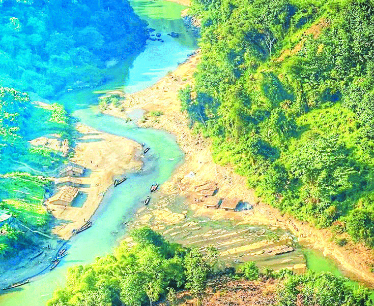
Navigational development and restoration will be done through excavation of Rangamati-Marisha and Rangamati-Thegamukh waterways of three hilly rivers Sangu, Matamuhuri and Karnafuli under the project.
The Project Evaluation Committee (PEC) meeting at the Planning Commission has prepared the working paper on the proposed project of BIWTA. The meeting raised questions about the additional cost of engineering surveys and other sectors. Under the project, total engineering survey work will be done in the area of 41.8 sq km for the navigable development and restoration of these three hilly rivers.
The Planning Commission has commented on the additional cost proposal, saying engineering survey costs are much lower than other similar projects. In the case of these three rivers, the commission has given its opinion on the reasons for the increase in project cost and rational determination of cost. The matter may come up at the next PEC meeting.
However, the BIWTA says that these three rivers should not be compared with other waterways. Because, these three rivers are located in hilly areas. The engineering survey work here is as risky as it is risky. Waterway excavation and engineering surveys in remote areas are relatively difficult. Dredging and soiling are also not easy. There are many kinds of challenges, which are not on the plane. For these reasons, additional expenditure has been proposed in other sectors including engineering survey of these three rivers. It would not be appropriate to call rivers in hilly areas and rivers in plains homogeneous.
The Chief Engineer (dredging)Abdul Matin said that it is difficult to work in any hilly area. For example, dredging and surveying the Sangu River is quite challenging. It is difficult to dig and remove the soil. Also, many dredging ships will not be able to go on the Sangu river. We have to look for alternative ways. Where the cost will be extra. For these reasons, rivers in hilly areas have been proposed to cost a little more in some sectors than other rivers in the plains.
Other ongoing development projects are estimated to cost Tk 180-250 per cubic meter of dredging with private dredgers, but the proposed project is estimated at Tk 350. The cost of construction of earthen dyke in the ongoing project is Tk 60-70 but Tk 120 has been taken in the proposed project.
In the proposed project, 2,130 km hydrographic survey has been proposed at a cost of Tk 10 crore 75 lakh. It has also been mentioned that a hydrographic survey will be conducted in the consulting sector. The duality of the hydrographic survey will be discussed at the PEC meeting.
One of the objectives of the project is to ensure smooth and safe movement of vessels throughout the year on three important rivers in the inland waterway. Both cargo and passenger vessels will be operated. To this end, ancillary works including excavation will be done for navigable development and restoration of rivers. The proposed cost of the project is Tk 1,261.63 crore. The project is scheduled to be implemented from July 1, 2022 to June 30, 2026.
The project is being implemented in Anwara, Banshkhali, Chapanaish, Satkania, Barkal of Rangamati, Jurachhari, Kaptai, Rangamati Sadar, Alikadam of Bandarban, Bandarban Sadar, Lama, Roangchhari, Ruma, Thanchi and Chakaria and Maheshkhali upazilas of Cox’s Bazar.
According to the BIWTA, 5 million cusecs (units of water flow measurement) of water and 2.4 billion tons of sediment are transported in the rivers of Bangladesh every year, which is 17.5 percent of the total silt transported in the world. Due to the large amount of silt being transported, the rivers are slowly dying and the navigability of the waterways is also decreasing. The project has been proposed on the Rangamati-Marisha and Rangamati-Thegamukh waterways of Sangu, Matamuhuri and Karnafuli rivers to divert the navigability.
Sangu river
The Sangu River originates in the Arakan Mountains of Myanmar. This hilly river enters Bangladesh through Remakri Union of Thanchi upazila of Bandarban district. The river flows northwards and then westwards to Thanchi, Roangchhari and Bandarban towns of the district and joins the Bay of Bengal through Satkania and Banshkhali upazilas of Chittagong.
Matamuhuri river
Matamuhuri is a transboundary river between Bangladesh and Myanmar. The river originates from the Lusai Hills in a hilly area on the border of Bangladesh and Myanmar in Alikadam upazila of Bandarban district in Bangladesh. The river flows north-west through Alikadam and Lama upazilas and flows westwards towards Chakaria upazila of Cox’s Bazar.
Karnafuli river
Karnafuli is a transboundary river between Bangladesh and India. The main river in the southeastern part of the country originates from Lusai Hills in Mizoram region of India and enters Bangladesh through Thegamukh of Bushan Chhara Union in Barkal upazila of Rangamati district. Later Kaptai Lake fell in Balukhali Union near Rangamati Sadar. Later, Kaptai met again in the Bay of Bengal near Patenga in Chittagong.
The main seaport of the country is Chittagong seaport at the mouth of this river. The length of the river is 320 km. The navigability of Rangamati-Marisha and Rangamati-Thegamukh of Karnafuli river will be diverted.
Major activities of the project
The project includes consultancy services. Capital dredging will be 181 lakh cubic meters. In addition, 75 lakh cubic meters of capital dredging or basic excavation will be done. The hydrographic survey will be 2,130 kilometers. 23 lakh cubic meters of soil dyke will be constructed. 36.28 lakh cubic meters of conservation dredging and 5.36 km of bank protective work will be done.
Meanwhile, the Planning Commission has raised questions about the cost of several sectors of the project. Consultation on office rent, car rental, rental of printer / computer equipment and plots, purchase of chairs, tables and ACs, field visits, hotel rent and transport sector expenditure allocation rationale, consultants’ salary allowance and monthly allocation.
Under the project, it has been proposed to purchase 20 computers (10 computers and 10 laptops), 14 printers (10 printers and four e-printers), four photocopiers, four scanners and six faxes against 12 officers / employees. However, it is learned that the PEC meeting will discuss the rationale for purchasing so many computer equipment in a project of river mining company.
The proposed project also includes the purchase of a jeep, two pickups and five motorcycles. However, the commission agreed to buy only one jeep.

President Joe Biden tests positive for COVID-19 while campaigning in Las Vegas, has ‘mild symptoms’
International Desk: President Joe Biden tested positive for COVID-19 while traveling Wedne…
Hotels to be converted for Covid hospitals
Hospitals overwhelmed Staff Correspondent: The government is going to rent hotels for providing treatment …
